|
Alice Springs squats at the geographic center of the
continent. One-tenth of its 25,000 residents are Aboriginal. The town
got its start as a repeater station on the Overland Telegraph Line,
which ran through Indonesia, Burma, India, and clear across to
London. This was the Net's big daddy - Australia's first international
communications system. The station was built beside a natural spring;
Alice was the boss's wife.
Alice Springs grew slowly: In 1925, it had just 200 residents, and
even now is the biggest settlement for 1,500 kilometers (1,000 miles)
in all directions. It's the center of a booming tourist industry,
based around Uluru (Ayers Rock) and Aboriginal culture. Racial
problems still exist, but nothing like the bad old days. This is the
only place on this trip where most of The Dreaming is whitefella
stuff.
Red earth, red rock, ruddy red skin confront you everywhere you
turn. Even the sun turns red, too, when it drops - but the surrounding
hills, the MacDonnell Ranges, turn an intense blue, as if internally
lit. The hills form a protective ring that almost appears to keep the
frightening void of the desert at bay. Nearby, red scars mark the dry
courses where mineralized, ultra-healthy water occasionally flows;
farther out, red kangaroos and wallabies haunt the ranges.
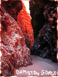
 Permanent waterholes - 60 million years in the making - floor breezy
gorges in West MacDonnell National Park. Stimpson's Gap, Stanley
Chasm, Ellery Creek, Serpentine Gorge, Ormiston Gorge, and Glen Helen
Gorge are sunk into 1.8 billion-year-old rock formations, the oldest
on this oldest of all continents. A 220 kilometer (140 mile) walking
trail, the Larapinta, is currently being forged through the park. If
you want to hike it, do so in winter, June to September.
|
